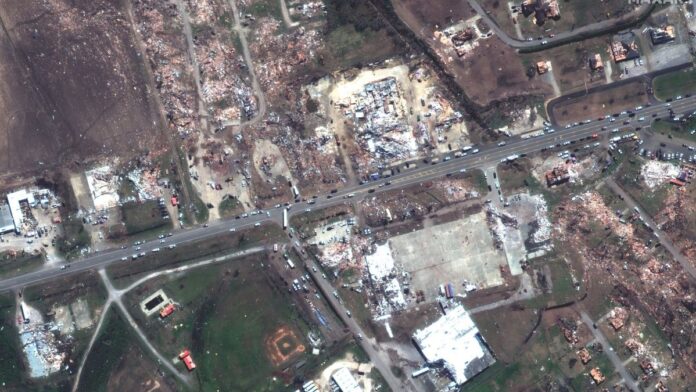
Haunting satellite imagery shows the aftermath of a severe tornado in Mississippi.
The small town of Rolling Fork, Mississippi was decimated yesterday (March 26) by a high-speed tornado that left at least 25 people dead, according to media reports. The community lies about 90 minutes north of Jackson and like many others, is facing more severe weather due to climate change.
Maxar satellites caught evidence of the destruction from Earth’s orbit, revealing information that may assist with disaster recovery. The photos show homes, buildings and other infrastructure torn to pieces by the E-4 tornado on a pathway moving from the southwest to the northeast through Rolling Fork’s heart.
Related: Climate change: Causes and effects

Rolling Fork has a population of 1,883 with a median household income of about $38,500 in 2020, United States census numbers show (opens in new tab). Roughly 20 percent of the population lives below the poverty line and most families identified themselves as Black or African-American.

The Washington Post (opens in new tab) noted that for many of these families, they have lost nearly everything and that despite commitments from all levels of government to help out, “everything that once stood for their lives is gone.” Some of the town lived in rental housing without insurance, for example.

Grants for temporary housing or for repairs are available in the region, which saw wind gusts of more than 166 mph (267 km/h). Given the amount of wreckage, the total numbers of casualties and the amounts of property damage are still being tallied.
Elizabeth Howell is the co-author of “Why Am I Taller (opens in new tab)?” (ECW Press, 2022; with Canadian astronaut Dave Williams), a book about space medicine. Follow her on Twitter @howellspace (opens in new tab). Follow us on Twitter @Spacedotcom (opens in new tab) or Facebook (opens in new tab).

