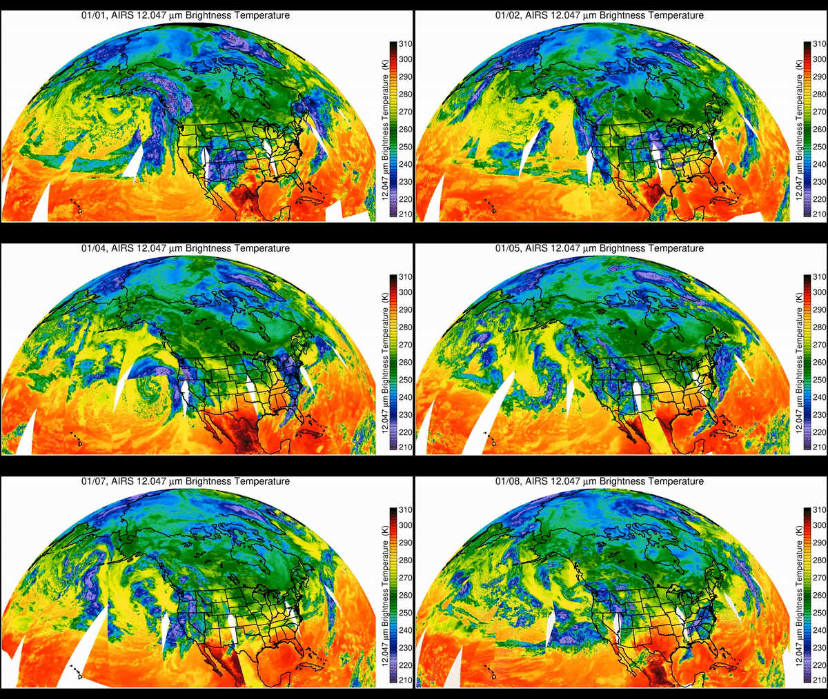
NASA has released satellite view showing California’s brutally wet start to the new year.
On Monday (Jan. 16), the state endured its last in a series of “atmospheric rivers” that carried storms dumping record-breaking rains over California. The storms have been battering the region since Dec. 26, killing at least 19 people according to Reuters and causing flooding, mudslides and infrastructure damage.
The series of storms are transported by an atmospheric river, a relatively narrow, windy region within Earth’s atmosphere capable of carrying moisture or tiny particles for thousands of miles. Usually between 250 miles and 375 miles (400 kilometers to 600 kilometers) wide, atmospheric rivers carry columns of water from the tropics like a river in the sky, moving with the weather. According to NASA’s Earth Observatory, these columns can hold water equivalent to up to 15 times the volume of the Mississippi River. When these atmospheric rivers make landfall they dump this water in the form of rain or snow.
Related: Satellites watch ‘atmospheric river’ bring extreme rain to California (photos)
This series of storms was imaged by NASA’s Atmospheric Infrared Sounder (AIRS), an instrument on the Aqua Earth-observing satellite that views the Earth in infrared light, which is not visible to the human eye. The animation AIRS produced showed the variation in cloud temperatures between Jan. 1 and Jan. 9, with cooler parts of the clouds linked to heavy rainfall.
Purple and violet areas in the AIRS images represent colder areas, with temperatures between minus 82 degrees Fahrenheit (minus 63 degrees Celsius) and minus 46 F (minus 44 C). Blue and green sections show clouds that are roughly minus 28 F (minus 33 C) to 26 F (minus 3 C).
Conversely, red sections are warmer, at between roughly 62 F (17 C) and 80 F (27 C), and represent mostly cloud-free air. White areas represent gaps in the AIRS data.
The parade of West Coast storms over the last ten days. pic.twitter.com/vOspSUDwg5January 16, 2023
The Aqua satellite was launched into orbit around Earth over 20 years ago, in May 2002. Since then, AIRS and its partner instrument the Advanced Microwave Sounding Unit (AMSU-A) have been vital in monitoring Earth’s atmosphere, providing data critical for weather forecasting and advancing our understanding of Earth’s climate.
AIRS is one of six instruments aboard Aqua, a satellite that is part of NASA’s Earth Observing System in low Earth orbit, making long-term global observations of our planet’s surface, biosphere, atmosphere and oceans. According to NASA, AIRS represents the most advanced atmospheric sounding system ever deployed in space.
The AIRS instrument consists of 2,378 infrared channels and 4 visible/near-infrared channels, while the AMSU-A instrument supplies an additional 15 microwave channels. This wide-spectrum observing technology allows the satellite to create detailed 3D maps of air and surface temperature, water vapor and cloud properties.
Finally some relief for California! As #GOESWest monitors the West Coast this morning, its water vapor imagery is showing one of the last major atmospheric river-associated storms in California moving out of the state and into the Four Corners region. #CAwx pic.twitter.com/JhPTtuxyipJanuary 17, 2023
The resolution of AIRS is over 100 times greater than that of previous infrared sounders, while its position in orbit around Earth means that it is available to rapidly observe any area of Earth.
Similar technology called radiosonde also measures pressure, temperature and relative humidity, but is deployed in a weather balloon, making coverage over much of the planet’s landmasses unfeasible and coverage over most of the globe’s oceans impossible.
According to NASA there are around 1,000 radiosonde launch sites globally, with the majority based in Europe and North America; most launch only two radiosonde-carrying balloons per day. In comparison, AIRS’ operations equate to launching 300,000 radiosonde instruments on a 30-mile (50-kilometer) grid over the globe each day, the agency noted.
Follow us on Twitter @Spacedotcom or on Facebook.

