New satellite images of Ukraine have revealed shocking scenes of death and destruction in the southern port city of Mariupol.
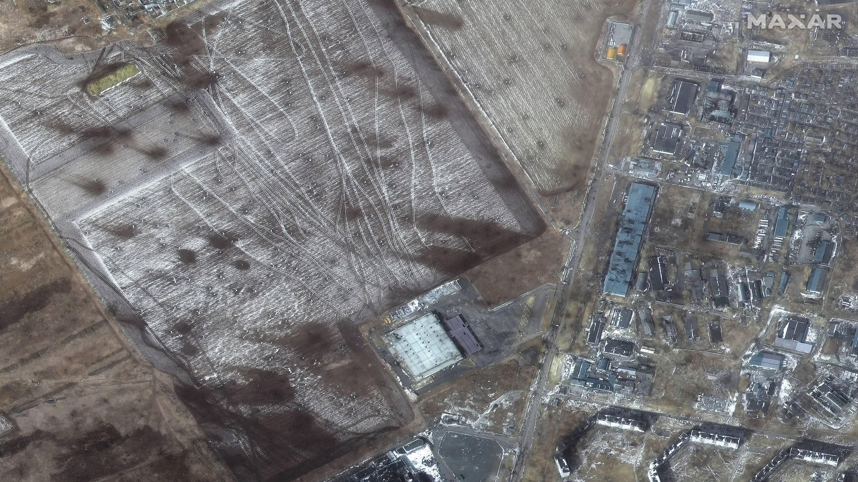
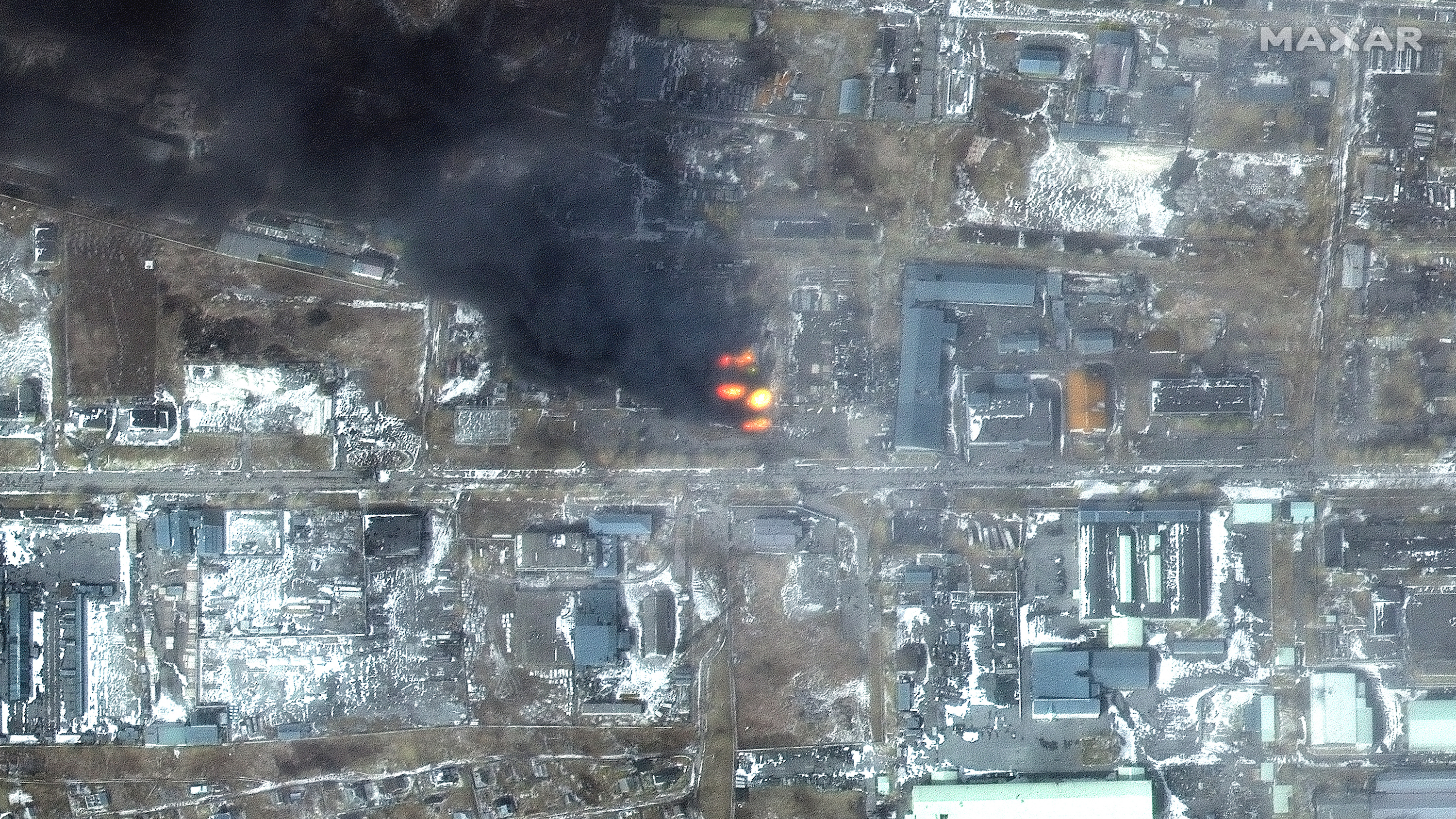
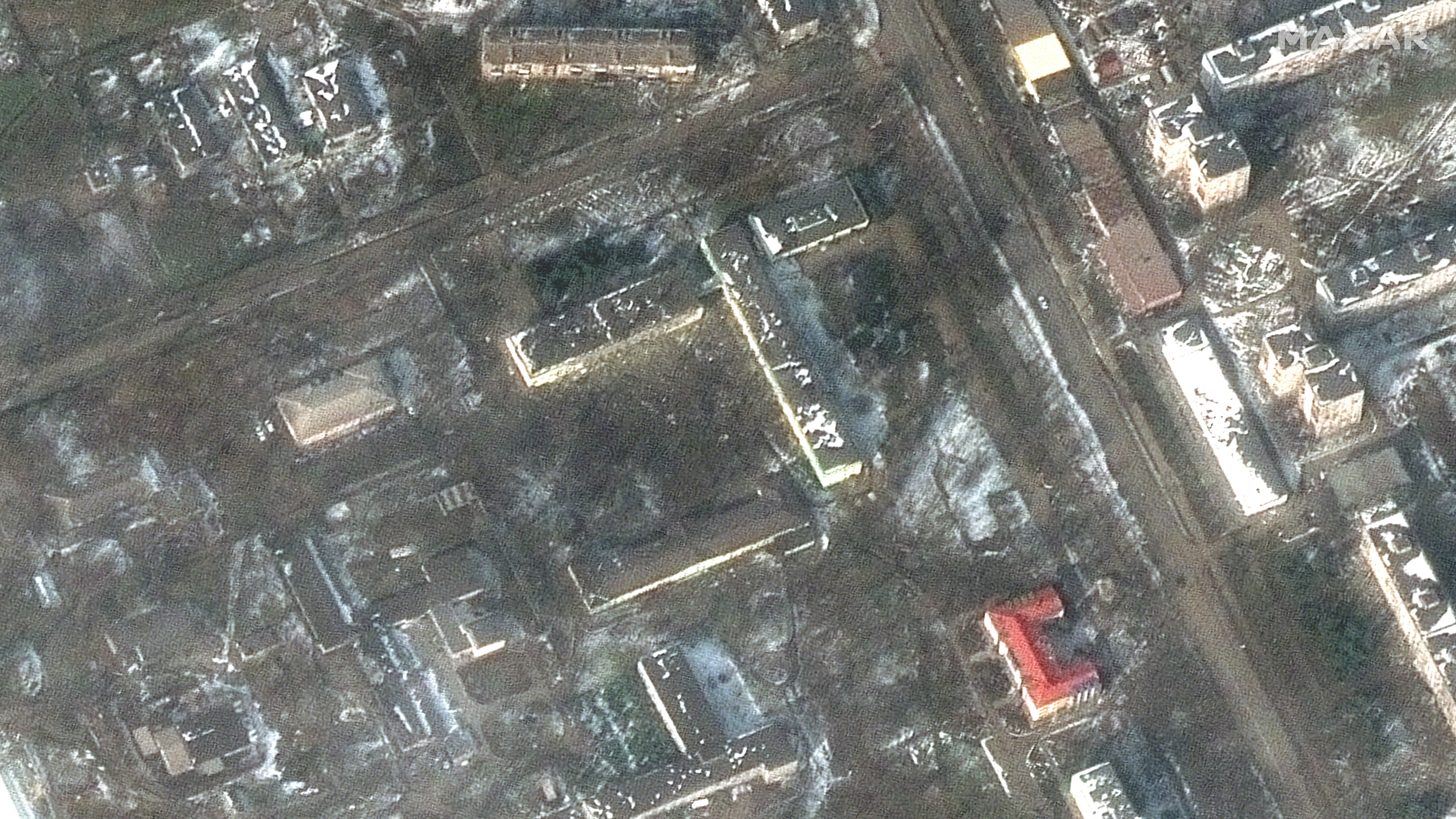
The images, taken by the U.S. private satellite company Maxar on Saturday (March 12) morning, reveal a hellish landscape of smoldering apartment blocks; parks pockmarked by shell fire; and grocery stores blasted into rubble by Russian missiles and artillery, which are hitting both civilian and military targets.
Mariupol, which is located in southeastern Ukraine on the north coast of the Sea of Azov, had a population of around 430,000 before the invasion began. Some were able to flee before Russian forces surrounded the city and cut off access to water, food, medicine, electricity and heat. Those who remain struggle to stay fed and warm, while avoiding incoming shells and the fires they spark.
Related: Russian invasion of Ukraine: Live updates
“The occupiers are cynically and purposefully hitting apartment buildings … destroying children’s hospitals and destroying the city’s infrastructure,” the Mariupol local council said in a statement on Sunday (March 13.). The council said that 2,187 civilians have been killed so far by the bombing, although an advisor to the Ukrainian president Volodymyr Zelenskyy, Oleksiy Arestovych, said this number has now risen to more than 2,500, according to Reuters.
Russia has dropped roughly 100 bombs on Mariupol since the siege of the city began 10 days ago, with at least 22 bombings taking place in a single 24-hour span, according to Mariupol local council. With morgues overwhelmed, many of the dead, among them a pregnant woman and her baby fatally injured after the bombing of a maternity ward, are being buried in mass graves.

Multiple attempts to set up humanitarian corridors to allow aid into the city and to enable civilians to flee have fallen apart, and Ukraine’s foreign ministry has accused Russian forces of shelling a humanitarian corridor leading to the city.
The International Committee of the Red Cross (ICRC) warned in a statement on Sunday (March 13) that time was “running out” for those still trapped in Mariupol and urged military forces that civilians must be allowed to escape the fighting “whether a formal safe passageway has been agreed to or not.”

“Hundreds of thousands of the city’s residents are now facing extreme or total shortages of basic necessities like food, water and medicine. People of all ages, including our staff, are sheltering in unheated basements, risking their lives to make short runs outside for food and water. Dead bodies, of civilians and combatants, remain trapped under the rubble or lying in the open where they fell,” an ICRC spokesperson said in the statement. “History will look back at what is now happening in Mariupol with horror if no agreement is reached by the sides as quickly as possible.”
Russia is placing a high strategic importance on the capture of the city, which would enable it to connect the Russian-held territories to the east with the Russian-annexed peninsula of Crimea, cutting off much of Ukraine’s access to the sea.
A handful of other companies besides Maxar are also providing a bird’s-eye view of the Russian invasion. The Planet and BlackSky satellite companies are capturing more optical spectrum images of the war’s impact on Ukraine, and Capella Space is scanning the region with its synthetic aperture radar, which can create detailed renderings of ground objects through cloud cover or at night.
Maxar also snapped satellite images of the Chernobyl nuclear plant after Russian forces seized the facility, cut off its power and held 210 plant staff as hostages, Live Science previously reported.
Originally published on Live Science.
New satellite images of Ukraine have revealed shocking scenes of death and destruction in the southern port city of Mariupol.
The images, taken by the U.S. private satellite company Maxar on Saturday (March 12) morning, reveal a hellish landscape of smoldering apartment blocks; parks pockmarked by shell fire; and grocery stores blasted into rubble by Russian missiles and artillery, which are hitting both civilian and military targets.

Mariupol, which is located in southeastern Ukraine on the north coast of the Sea of Azov, had a population of around 430,000 before the invasion began. Some were able to flee before Russian forces surrounded the city and cut off access to water, food, medicine, electricity and heat. Those who remain struggle to stay fed and warm, while avoiding incoming shells and the fires they spark.
Related: Russian invasion of Ukraine: Live updates
“The occupiers are cynically and purposefully hitting apartment buildings … destroying children’s hospitals and destroying the city’s infrastructure,” the Mariupol local council said in a statement on Sunday (March 13.). The council said that 2,187 civilians have been killed so far by the bombing, although an advisor to the Ukrainian president Volodymyr Zelenskyy, Oleksiy Arestovych, said this number has now risen to more than 2,500, according to Reuters.
Russia has dropped roughly 100 bombs on Mariupol since the siege of the city began 10 days ago, with at least 22 bombings taking place in a single 24-hour span, according to Mariupol local council. With morgues overwhelmed, many of the dead, among them a pregnant woman and her baby fatally injured after the bombing of a maternity ward, are being buried in mass graves.

Multiple attempts to set up humanitarian corridors to allow aid into the city and to enable civilians to flee have fallen apart, and Ukraine’s foreign ministry has accused Russian forces of shelling a humanitarian corridor leading to the city.
The International Committee of the Red Cross (ICRC) warned in a statement on Sunday (March 13) that time was “running out” for those still trapped in Mariupol and urged military forces that civilians must be allowed to escape the fighting “whether a formal safe passageway has been agreed to or not.”

“Hundreds of thousands of the city’s residents are now facing extreme or total shortages of basic necessities like food, water and medicine. People of all ages, including our staff, are sheltering in unheated basements, risking their lives to make short runs outside for food and water. Dead bodies, of civilians and combatants, remain trapped under the rubble or lying in the open where they fell,” an ICRC spokesperson said in the statement. “History will look back at what is now happening in Mariupol with horror if no agreement is reached by the sides as quickly as possible.”
Russia is placing a high strategic importance on the capture of the city, which would enable it to connect the Russian-held territories to the east with the Russian-annexed peninsula of Crimea, cutting off much of Ukraine’s access to the sea.
A handful of other companies besides Maxar are also providing a bird’s-eye view of the Russian invasion. The Planet and BlackSky satellite companies are capturing more optical spectrum images of the war’s impact on Ukraine, and Capella Space is scanning the region with its synthetic aperture radar, which can create detailed renderings of ground objects through cloud cover or at night.
Maxar also snapped satellite images of the Chernobyl nuclear plant after Russian forces seized the facility, cut off its power and held 210 plant staff as hostages, Live Science previously reported.
Originally published on Live Science.

